
Overview - Timescale, Physical Landscapes
GEOL.3310 :: Phanerozoic Eon (538.8 ± 0.2 – 0 Ma) :: Mesozoic Era (251.902 ± 0.024 – 66.0 Ma) :: Mesozoic Era (251.902 ± 0.024 – 66.0 Ma) :: Jurassic Period (201.4 ± 0.2 – ~145.0 Ma)
Page 1 of 1

Overview - Timescale, Physical Landscapes
![]() by Jacob Sultan Mon Apr 24, 2023 10:02 pm
by Jacob Sultan Mon Apr 24, 2023 10:02 pm
During this period, the supercontinent Pangea broke apart to form the present-day mid-Atlantic and Gulf of Mexico. Plate tectonics increased, volcanic and orogenic activity increased and islands were connected to continents. Shallow sea routes covered many continents, depositing submarine and marginal sediments and preserving a wide variety of fossils. Jurassic rock strata produced natural resources such as gold, coal and oil.
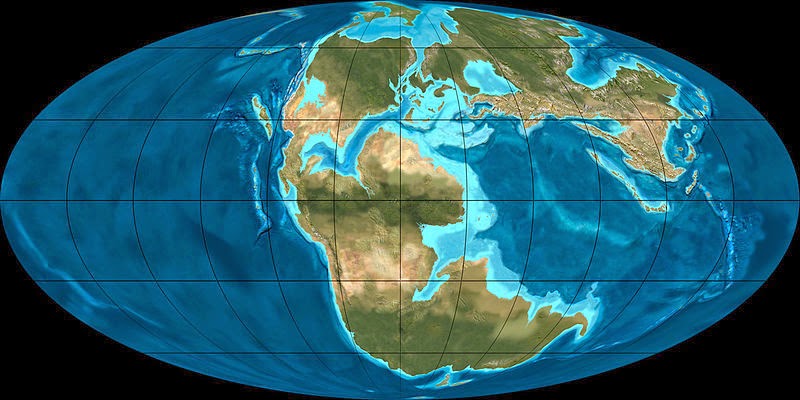
The breakup of the supercontinent Pangea began during the Triassic period, but the continents were still close together during the early Jurassic. The two regions are classified as Laurasia, the northern region that includes North America and Eurasia, and Gondwana, the southern region that includes South America, Africa, India, Antarctica and Australia. These two regions are separated by the Tethys, a tropical east-west seaway. During the Jurassic period, diffusion centers and oceanic rifts formed between North America and Eurasia, between North America and Gondwana, and between parts of Gondwana.
In response to the formation of a new seafloor along the Proto-Atlantic, significant subduction zones (where the seafloor was destroyed) were active along almost all continental margins around Pangea, as well as in southern Tibet and southeastern Europe.
- 201.3 - 145 ma
- Division of Mesozoic era
Phanerozoic eon - Jurassic Period
- Lower
- Hettangian
- Sinemurian
- Pliensbachian
- Toarcian
- Middle
- Aalenian
- Bajocian
- Bathonian
- Callovian
- Upper
- Oxfordian
- Tithonian
The breakup of the supercontinent Pangea began during the Triassic period, but the continents were still close together during the early Jurassic. The two regions are classified as Laurasia, the northern region that includes North America and Eurasia, and Gondwana, the southern region that includes South America, Africa, India, Antarctica and Australia. These two regions are separated by the Tethys, a tropical east-west seaway. During the Jurassic period, diffusion centers and oceanic rifts formed between North America and Eurasia, between North America and Gondwana, and between parts of Gondwana.
In response to the formation of a new seafloor along the Proto-Atlantic, significant subduction zones (where the seafloor was destroyed) were active along almost all continental margins around Pangea, as well as in southern Tibet and southeastern Europe.

Jacob Sultan- Admin
- Posts : 48
Join date : 2023-04-23
Location : UMass Lowell -

» Overview - Timescale, Physical Landscapes
» Overview - Timescale, Physical Landscapes
» Overview - Timescale, Physical Landscapes
» Overview - Timescale, Physical Landscapes
» Overview - Timescale, Physical Landscapes
» Overview - Timescale, Physical Landscapes
» Overview - Timescale, Physical Landscapes
» Overview - Timescale, Physical Landscapes
» Overview - Timescale, Physical Landscapes
GEOL.3310 :: Phanerozoic Eon (538.8 ± 0.2 – 0 Ma) :: Mesozoic Era (251.902 ± 0.024 – 66.0 Ma) :: Mesozoic Era (251.902 ± 0.024 – 66.0 Ma) :: Jurassic Period (201.4 ± 0.2 – ~145.0 Ma)
Page 1 of 1
Permissions in this forum:
You cannot reply to topics in this forum|
|
|